With climate change and atmospheric warming, weather phenomena are becoming increasingly unpredictable and intense. We are witnessing devastating wildfires, tornadoes, sandstorms, unprecedented floods, and landslides, even in areas that historically haven’t experienced such events.
The connection between national security and the effects of climate change has been a central topic of discussion at the Austrian World Summit, an annual climate conference held in Vienna since 2017.
The first step towards solving a problem is to acknowledge its existence.
The second step is to monitor it so that we can take action.
Infrastructure: What do we currently have?
Monitoring extreme weather events and climate change is essential in our strategy to combat their effects. Whether it’s technical studies like the IPCC, geopolitical actions taken through conferences like COP, or national actions by governments, studying and monitoring the effects of climate change are key factors for adapting, mitigating, and addressing the new problems we face globally and locally.
Currently, the systems for monitoring extreme weather events are becoming increasingly complex, but there is still room for progress in this field. Therefore, we can initially distinguish two categories of systems:
Global systems:
– GDACS (Global Disaster Alert and Coordination System)
– Copernicus EMS Early Warning and Monitoring
– European Plate Observing System
National systems (Romania):
– Air quality monitoring – www.calitateaer.ro (only in cities)
– Water quality monitoring – Romanian Waters (no digitalization/real-time information)
– Flood monitoring – risk maps (no digitalization/real-time information)
– RO-ALERT system (used in major situations where the life and health of citizens are endangered, such as extreme weather events, floods, or other situations that seriously threaten communities)
Private systems using IoT technology (Internet of Things) that refers to the collective network of connected devices and the technology that facilitates communication between devices and the cloud, as well as between devices themselves.
– Air quality monitoring – Strop de Aer/Uradmonitor
– Water quality monitoring – Strop de Rouă
– Vegetation fire monitoring – Spot Fire
– Flood monitoring – River Guard
What solutions do we have, and what would be a strategy to follow?
A first step would be to develop a complex system for detecting, monitoring, analysing, and forecasting hazards and their potential consequences using state-of-the-art technology (including ground data and satellite imagery). This system should be led by a cellular structure composed of specialists in key domains, working in real-time with information related to national security and protection.
Multiple natural disaster detection systems refer to the process of simultaneously detecting and monitoring multiple natural disasters such as earthquakes, floods, hurricanes, and fires using various technologies, including sensors, satellites, and other remote sensing technologies. This system is used to provide early warnings and responses to natural disasters, which can contribute to reducing damages and human casualties caused by these events.
Detecting multiple natural disasters requires integrating data from various sources, such as meteorological data, seismic data, and satellite imagery. These data are processed using machine learning algorithms to identify patterns and anomalies that could indicate the occurrence of a natural disaster.
These systems utilise various technologies, including satellite imagery, sensors, and artificial intelligence, to monitor and detect natural disasters. For example, NASA’s Earth Observing System (EOS) provides a global view of Earth’s climate, oceans, land, and atmosphere, which can be used to detect and monitor natural disasters.
Generally, multiple natural disaster detection systems are essential in order to provide early warnings and responses to natural disasters, which can contribute to mitigating damages and human casualties caused by these events.
Technical aspects:
An early warning system would require a solid scientific foundation and reliable technology for real-time or near-real-time monitoring and detection of hazards, as well as providing forecasts and alerts 24/7 throughout the year. The system should also be monitored and equipped with qualified personnel assisted by state-of-the-art equipment and computing power capable of interpreting and detecting anomalies in real-time.
Continuous monitoring of hazard parameters and their precursors (where available for a specific hazard) is essential to generate timely and precise warnings, allowing affected communities sufficient time to implement appropriate disaster management plans. Alert services should have a multi-risk perspective (e.g., heavy rainfall can trigger not only floods but also landslides, with alerts coming from separate authorities based on risk maps) and should be coordinated whenever possible to benefit from common institutional, procedural, and communication networks and capacities.
Data, forecasts, and alerts should be archived in a standardised manner to support post-event analysis and system improvement over time.
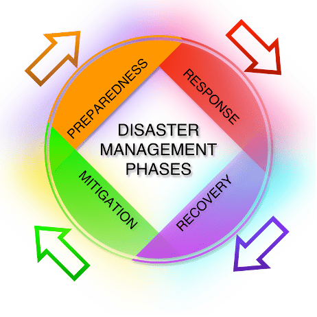
Telecommunications are essential in all stages of disaster management: mitigation, preparedness, response and assistance, recovery and rehabilitation
Human resources aspect:
Here, the integration of a plethora of key actors is needed, such as:
- national and local disaster management agencies
- scientific and technical agencies
- meteorological and hydrological organisations
- health authorities
- ocean observation organisations and geophysical agencies
- universities and research institutes
- equipment providers from the private sector
- telecommunications authorities; security experts; military authorities; quality management experts; regional technical centres.
In short, a Multi-Hazard Disaster Management Plan should be developed for the safety and security of each country:
Natural hazards include earthquakes, cyclones, tornadoes, floods, landslides, droughts, tsunamis, volcanic eruptions, and fires. For all disasters following natural hazards, the developed system plays an essential role in facilitating the flow of vital information in a timely manner.
To mitigate the devastating effects of hazards, the developed system will utilise various technologies and information and communication networks, including satellites, radio, mobile networks, and the internet, which can contribute to increasing the capacity and reducing the vulnerability of the population.
Local community, government, private sector, disaster management agencies, meteorological organisations, civil society, humanitarian agencies and international organisations should provide access to the developed system for better coordination of disaster management activities. Partnerships are the best way to accomplish this task.
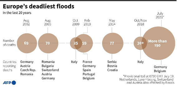
Disasters began to be more and more present in our lives, thus floods claimed victims year after year.
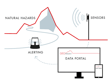
Therefore, critical event detection and monitoring systems have emerged in Europe for each type of disaster: avalanches or rock falls, floods, alerting and warning.
A warning system in case of natural disasters is offered by a private actor called TELEGRAFIA.
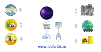
Another concept only at the level of MVP (Romania) is the private solution IOT4CRISIS, a system for protecting the national security infrastructure consisting of a network of IOT devices that can detect natural disasters (earthquakes, landslides, floods, atmospheric pollution or fires) as well as man-made disasters.
Such a system could be developed using several funding sources (European or national), involving actors from the private sector, research or defence.
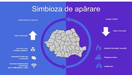
A complete solution should contain a network of systems, each system detecting a different hazard.
This network should use several communication protocols to ensure data transmission regardless of the extreme weather phenomena occurring in their vicinity (GSM, LoRa, SigFox, LTE, Radio). Satellite communication is to be taken into account.
Also, a parallel power supply (UPS) to ensure functionality in the event of a power failure, would be a must for these systems.
The implementation of a minimum of two sets of sensors (redundancy) to compare measurements in real time would be an example of good practice, given that the system will be of national safety and importance.
The sensitivity of the sensors and their category should be of military construction, withstand at least 10 years of 24/7 operation as well as weather, high humidity or extreme temperatures.
Data storage should be done on multiple external media, encrypted and uploaded to the cloud every second. A series of Machine Learning algorithms or Mega Computers should study the collected data and information and immediately identify reading errors, anomalies or deviations from normal functionality and monitoring.
Image processing systems are already an advantage and based on the analysis, slope movements, avalanches, floods and any phenomenon that has several characteristics and requires additional information for their recognition can be detected. Thus, the video cameras will be part of the complex system for detecting natural disasters in real time.
It is certain that predicting and estimating the duration of climate events can save and prevent the loss of resources and human lives. We have reached the time when we can use technology to buy more time when we are talking about emergency situations or critical events.

He worked for nine years in industrial automation (factories, refineries, CETs, power plants). He has been working in the IT field as an intelligent systems specialist for five years. He is the founder of several environmental projects including: Strop de aer (stropdeaer), Strop de roua (stropderoua), SpotFire (spotfire.ro), Air Quality Ambassador – OpenAQ.


